Konflikti Kiinan merellä

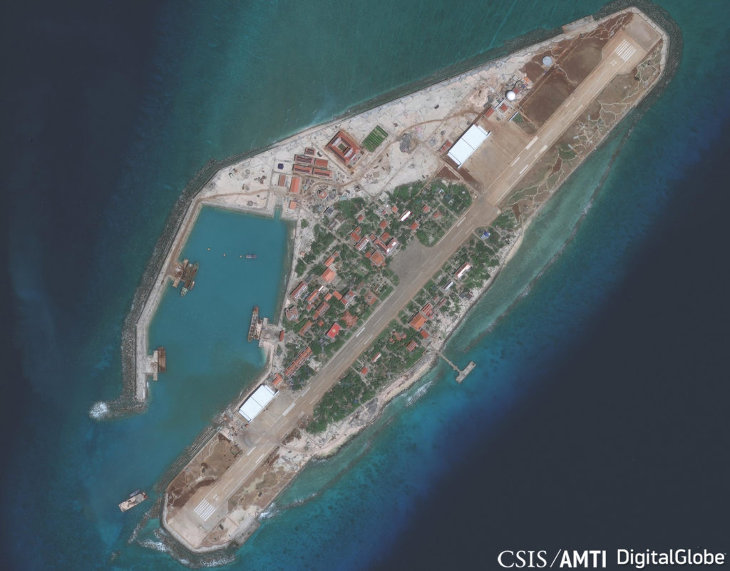
Aiemmin levisi uutinen jossa Kiinalainen amiraali ehdotti törmäämistä Usan laivoihin. Nyt toinen amiraali, kiinan haukkoja yhtyy kuoroon. Upottakaa vaikka ohjuksella yksi tai kaksi Usan lentotukialusta ja Usa vetäytyy. Breiking spirit, Bloody nose taktiikkaa. Merkittävintä näissä haukkojen ulostuloissa on, että tiukan sensuurin maa Kiina antaa koko maailman kuulla niistä. Vaikka eivät edusta Kiinan virallista linjaa, niin edustavat silti.

Sanotaan, että Usa pelkää kaikkein eniten uhreja. Yksi lentotukialus voisi tuoda 5000-uhria. Se voisi ajaa jenkit pois alueelta.

Toisaalta jutussa jenkkiamiraali toteaa, että antaa räksyttää. Outoa se olisi ollutkin jos olisivat kertoneet, että rakennamme lentotukialuksia hölmönä vain sen vuoksi, että jenkit voi lanata ne kolmen ensimmäisen sotapäivän aikana.

https://read.bi/2QFhD6o
 
Usa siirtää B-2 koneita tyynelle merelle harjoittelemaan Kiinan uhan vuoksi.

The major general added that the deployment "helped ensure a free and open Indo-Pacific," rhetoric the US uses regularly to describe moves meant to counter Chinese actions perceived as aggressive or coercive.

https://read.bi/2VNAf8h
 
Voisivat kysyä Japanilta, miten hyvin tuo toimi Pearl Harborissa. Länsimaista USA pelkää uhreja kaikista vähiten - ja länsimaista vähiten USA sietää arvovaltansa loukkaamista.

Puhumattakaan siitä, kuka on tällä hetkellä presidenttinä. Jotenkin tuntuu, että kiinan kannattaisi pitää turpaa pienemmällä ihan sen takia että Trump tunnetusti haluaa viimeisen sanan melkeimpä joka tilanteessa. Tässä tapauksessa Trump luultavasti tekisi sen painamalla nappia.
 
Hyvä katsaus kiinanmeren tilanteeseen. Kukaan ei halua sitä konfliktia, mutta on melko varma jos tunteet kuumenee niin kiinanmeri menee sulkutilanteeseen.
  • We explore the U.S.-China relationship beginning with tensions in and around the South China Sea.
This episode is broken up into three parts:

  1. How did all this begin? (at the 2:58 mark)
  2. What’s in it for Beijing? (11:16)
  3. Where to go and what to know from here (24:28)
https://www.defenseone.com/ideas/20...sions-part-one-tinderbox/154753/?oref=d-river
 
China largely abandoned a hacking truce negotiated by Barack Obama as President Donald Trump embarked on a trade war with Beijing last year, according to the cybersecurity firm Crowdstrike Inc.

A slowdown in Chinese hacking following the cybersecurity agreement Obama’s administration secured in 2015 appears to have been reversed, the firm said in a report released Tuesday that reviewed cyber activity by U.S. adversaries in 2018.

“By 2017 they started coming back and throughout 2018 they were back in full force,” said Adam Meyers, vice president of intelligence at Crowdstrike. “They have been very active and we expect to see that continue.”
https://www.bloomberg.com/news/arti...dons-cybersecurity-truce-with-u-s-report-says

Huolestuttavaa. Voiko vakava kyberkeissi aiheuttaa konfliktin supervaltojen välille?
 
Compared with China’s other maritime disputes, which involve territorial sovereignty and maritime delimitation in the Yellow Sea, the East China Sea, and the South China Sea, the issue underpinning disputes over freedom of navigation is more of a theoretical debate. Rather than centering on irreconcilable claims of ownership that run against China’s core interests of national unity, territorial integrity and development, the dispute is instead one of how the sea should be utilized and how it should be governed. There is space for consultation between China and the United States here. As China’s relative strength vis-à-vis its neighbors grows in the South China Sea, maintaining stability is a top priority. Keeping a low profile and avoiding conflict between China and the United States in the South China Sea should be China’s long-term policy. Resolving divergent opinions over freedom of navigation through careful negotiation, and amending domestic laws and policies on innocent passage or military use of the EEZ, while seeming on their face to be concessions, would indeed be a path of major progress toward oceanic power for China.
https://amti.csis.org/how-china-can-resolve-fonop-deadlock/
 
Over the past few years, China has dominated the South China Sea disputes and, subsequently, secured the acquiescence of most other claimant states. Now, it has fixed its gaze on gaining a foothold in strategic locations and sectors of those claimants, a strategy that—in a nod to its layered paramilitary strategy—could be called its “economic cabbage strategy”.

From Malaysia to Maldives, China has sought to dominate critical infrastructure across sea lines of communications, gradually building a global network of access and dependencies, often at the expense of smaller nations’ sovereignty.

Under this approach, Chinese companies—most of them state-affiliated if not state-owned enterprises—zero in on prized infrastructure projects in critical sectors like electricity, telecommunications, police surveillance projects, and, most recently, major port facilities.

The blossoming Philippines-China relationship has opened a floodgate of Chinese investments, unnerving domestic players including the influential military establishment. In particular, China’s bid for a 300-hectares shipping yard in Subic Bay, the former site of one of the United States’ largest overseas naval bases, has unleashed a political firestorm, exposing the fragility of the ongoing rapprochement and the resilience of Beijing-skeptic sentiments in the Southeast Asian country.
https://amti.csis.org/chinas-economic-cabbage-strategy/

The recent visit of U.S. secretary of state Michael Pompeo to Manila settled a long-standing concern in the Philippines over U.S. commitment to Philippine security in the South China Sea. In a press briefing with Philippine secretary of foreign affairs Teodoro Locsin, Jr., Pompeo unequivocally articulated what the Obama administration never publicly did: “As the South China Sea is part of the Pacific, any armed attack on Philippine forces, aircraft or public vessels in the South China Sea will trigger mutual defense obligations under Article 4 of the [1951] Mutual Defense Treaty [MDT].”

Article 4 expressly provides that “an armed attack in the Pacific Area on either of the Parties” would require each nation to “act to meet the common dangers in accordance with its constitutional processes.” In reference to this, Article 5 of the MDT clarifies: “an armed attack on either of the Parties is deemed to include… its armed forces, public vessels or aircraft,” as well as metropolitan and island territories.

Pompeo’s policy statement should not come as a surprise; the U.S. Navy’s routine freedom of navigation operations (FONOPS) in the South China Sea and passages through the Taiwan Strait underscore a renewed effort to demonstrate U.S. security concerns in the newly-dubbed INDOPACOM, or Indo-Pacific Command, area of responsibility. But while Pompeo’s reassurance on the MDT’s geographic scope may assuage Philippine anxiety over one aspect of the treaty, the agreement is more complicated than that, and some in Manila worry more over just what circumstances would persuade Washington to uphold the treaty—or demand that it be upheld.
https://amti.csis.org/outstanding-issues-philippines-u-s-alliance/
 
Onko US tai liittolaiset tehneet samalla taktiikalla tuolla omia saaria?
Jotenkin odotan vastaavaa siirtoa sekä tuolla aasiassa, että Venäjän tekemänä itämerellä. Johonkin Kaliningradin ja Götlannin väliin olisi hyvä pistää joku yllättävä "saari"...
 
Onko US tai liittolaiset tehneet samalla taktiikalla tuolla omia saaria?
Jotenkin odotan vastaavaa siirtoa sekä tuolla aasiassa, että Venäjän tekemänä itämerellä. Johonkin Kaliningradin ja Götlannin väliin olisi hyvä pistää joku yllättävä "saari"...

Tai Suomenlahden suulle...
 
Tai Suomenlahden suulle...
Sellasia lomasaaria taitaa olla jo Turun saaristossa useampia. Lyhyttukkaiset venäjää puhuvat urheilijanuorukaiset käyvät ansaituilla lomillaan harjoittelemassa sot...olympialaisiin, samalla kun kiikaroivat laiv...lintuja ja muuta luontoa.
 
senkaku.jpg


The public discussion of South China Sea FONOPs most often focuses on those that take place within 12 nautical miles of disputed features. Those operations are meant either to challenge China’s demand for prior notification for innocent passage through the territorial sea or to assert that there is no territorial sea around naturally submerged banks and reefs. But the steady pace of U.S. and now UK operations challenging China’s declared baselines around the Paracels warrants just as much attention, both because of the egregiousness of that claim and because of a fear that Beijing will soon declare similar baselines around the Spratlys.

In 1996, China declared a series of straight baselines around the Paracel Islands from which its territorial sea should be measured. That not only extended Beijing’s territorial sea claim by asserting it should be measured from the grouping as a whole rather than from individual islands; more importantly, it declared all the space within the baselines China’s internal waters. As a result, Beijing insists that foreign vessels have no rights to transit through or fly over the waters between the Paracels, even if they are farther than 12 nautical miles from any individual island. This is the claim that the Albion and numerous U.S. FONOPs have challenged.

paracels.jpg


The arbitral tribunal hearing Manila’s case against Beijing’s South China Sea claims considered the question of whether a coastal state like China might be able to enclose offshore archipelagos (in that case, the Spratlys) with baselines. It found that UNCLOS “excludes the possibility of employing straight baselines in other circumstances [than those expressly listed in the convention], in particular with respect to offshore archipelagos not meeting the criteria for archipelagic baselines.”

But even setting that legal hurdle set aside, UNCLOS still establishes rules that must be followed in setting archipelagic baselines. The two simplest are that the baseline segments cannot, for the most part, be longer than 100 nautical miles, and that the ratio of water to land enclosed by the baselines cannot exceed 9 to 1. China’s baselines around the Paracels meet the first of these. But they far exceed the second limit. Even including all of the new land Beijing created by dredging and landfill in recent years, there is only about 9.11 square kilometers of land in the Paracels. The baselines, meanwhile, enclose some 17,290 square kilometers of water. That is a ratio of 1,898 to 1.
https://amti.csis.org/reading-between-lines-next-spratly-dispute/
Beijing could decide to ignore all the precepts of UNCLOS and enclose every feature it considers part of the Nansha Qundao within baselines. This would include not only the Spratly Islands, but the entirely underwater Luconia Shoals and James Shoal off Malaysia, as well as Vanguard Bank and other submerged features on the continental shelf of Vietnam. Beijing has consistently ignored the reality that these reefs and banks are underwater, insisting that they are part of the collective whole of the Nansha Qundao. By the same logic, China maintains that the Zhongsha Qundao is a single island group and will one day be enclosed by baselines, despite Macclesfield Bank and the rest of the group except for Scarborough Shoal being underwater. Pursuing this model might enclose about 230,769 square kilometers of ocean within baselines. In contrast, there is only about 17.3 square kilometers of land in the Spratlys by the most generous method of counting (the roughly 4 square kilometers that existed naturally, plus the 13.3 square kilometers created artificially by all parties). That results in a water to land ratio of 13,339:1.

scenario1.jpg

In any form, a baselines declaration in the Spratlys would escalate tensions in the region. Claimants like the Philippines and Vietnam would find disputed seas, including those immediately around some of their outposts, suddenly labeled China’s internal waters closed to foreign planes and ships. The United States and other outside parties would also be sure to undertake operations to signal their nonrecognition of those internal waters. And both commercial shipping and airline companies would face the possibility of China attempting to close previous routes through and above these baselines.
 
Niille jolla riittää mielenkiintoa tuo yläpuolinen artikkeli antaa melko selvän kuvan kuinka Kiinalaisten vaatimukset ovat suhteettomia verrattuna siihen mitä muut maat voivat vaatia luonnollisesti. Iso kysymys on Kiinan ollessa jääräpäinen suurvalta, miten se taivutetaan samaan ruotuun muiden kanssa?

super.gif


ja moderni heat map nykyisestä liikenteestä

4869-01.jpg


Jos Kiinalle annetaan periksi sen "9-dash line" niin he voivat halutessaan tehdä laivaliikenteestä todella vaikean.
 
Viimeksi muokattu:
USS-Wasp-600x350.jpg


In the latest show of military muscle in the South China Sea, the U.S. has apparently sailed its USS Wasp amphibious assault ship near a strategic reef claimed by Beijing and Manila that lies just 230 km (140 miles) from the Philippine coast.

Filipino fishermen near the site known as the Scarborough Shoal initially spotted what appeared to be the massive U.S. vessel on Tuesday, according to ABS-CBN News. It said planes were seen landing and taking off from the ship, some 5 km (3 miles) away from the fishermen’s boat. A video clip shown by the news network appeared to corroborate their account.

Contacted by The Japan Times, a U.S. military spokeswoman would not confirm or deny the Wasp’s presence near the collection of outcroppings that barely jut out above water at high tide, citing “force protection and security.” However, the spokeswoman did confirm that the Wasp “has been training with Philippine Navy ships in Subic Bay and in international waters of the South China Sea … for several days.”
https://warisboring.com/u-s-sails-massive-f-35-laden-warship-in-disputed-south-china-sea/

China covets Scarborough Shoal for its strategic significance, experts say, as it would be the crowning jewel in a bid to solidify Beijing’s iron grip over the South China Sea. They say building at Scarborough would create a large “strategic triangle” comprising Woody Island in the Paracel Islands to the northwest and its Spratly islet outposts to the south, giving Beijing the ability to police an air defense identification zone (ADIZ) in the South China Sea.

The impact of such a strategic triangle — which would bring the entire region under Chinese radar, missile and air coverage — would be tremendous for both the United States’ and Japan’s strategic planning, some experts say, and could be a game-changer in regional power relations.

But any decision by China to forcefully take over the collection of outcroppings for land-reclamation purposes would likely be met with resistance by the U.S., the Philippines and others.
 
Spratly_10_20_18_DGWM-1600-1-1024x801.jpg

Vietnamilaisten Spartley.

Vietnam continues to quietly upgrade its facilities in the Spratly Islands, though apparently without facing the same reaction from China’s maritime militia forces as the Philippines recently has. Vietnam occupies 49 outposts spread across 27 features in the vicinity of the Spratly Islands. Of those 27 features, only 10 can be called islets while the rest are mostly underwater reefs and banks.
https://amti.csis.org/slow-and-steady-vietnams-spratly-upgrades/

Linkin alla enemmän infoa ja lisää kuvia.
 
Jos katselette Seal Teamia niin kaksi viimeisintä episodia on tällä konflikti alueella.
 
Back
Top