UAV / UCAV / LAR (robotit) Uutiset ja jutut

  • Viestiketjun aloittaja Viestiketjun aloittaja Raveni
  • Aloitus PVM Aloitus PVM
Joulet lasketaan muuten 0.5 x massa x nopeus^2. Käytännössä dronessa pitäisi olla tietyssä nopeudessa tai yhteyden katketessa laukeava laskuvarjo tuon alittamiseksi.

Mitä jos lisään droneen DSP (digitaalinen signaali prosessori) ja kirjoitan sille ohjelman joka haistaa kohinan voimistumista taajuuskanavalla ja sen ylittäessä tietyn pisteen, drone lähettää signaalin takaisin operaattorille ja vaihtaa taajuutta toiseen? Antenni tietysti rajoittaa tätä toimintaan, mutta tuolla tavalla voi periaatteessa väistää hillotusta. Totaalisen hillotuksen ollessa kyseessa palaa kotia taikka tekee jotakin muuta.

Kaupallisissa tälläistä ei löydy, mutta teoriassa vihollisdronesta tälläinen voi löytyä. Syyriassa on näkynyt itsekasattuja droneja, joten ajattelen vain että missä vaiheessa euroopassa nähdään ensimmäinen dronetero? Onko konsepti liian monimutkainen psykoottiselle massamurhaajalle?
Modernit hillottimet seuraavat laajaa taajuusaluetta. Ongelmaksi tuo muodostuu lähinnä jos vihulainen käyttää samaa taajuutta kuin omatkin.
 
Eikö tuo ole helppo laskea: maksiminopeus jolla laite voi lentää/pudota * laitteen massa.

Joo. On helppo laskea, mutta miksi he eivät suoraan sano että kaikki dronet luokitellaan painon ja nopeuden suhteen, kuin törmäysenergian. Sillä norjalaisten suosimalla minikopterilla on mahdollisuus saada aikaan pahaa jälkeä erittäin tuulisilla olosuhteilla. Kaikki on suhteellista erikoistilanteissa.
 
Modernit hillottimet seuraavat laajaa taajuusaluetta. Ongelmaksi tuo muodostuu lähinnä jos vihulainen käyttää samaa taajuutta kuin omatkin.

Jos kenenkään dronet ei liiku hillotus-alueella niin ollaan tasa-arvoisessa tilanteessa. Ongelma minkä ajattelin kanssa on että mitä jos drone hillotuksen huomatessaan suorittaa tehtävän ja hakeutuu autonomisesti lähimpään kohteeseen, oli se sitten mikä tahansa?
 
Joulet lasketaan muuten 0.5 x massa x nopeus^2. Käytännössä dronessa pitäisi olla tietyssä nopeudessa tai yhteyden katketessa laukeava laskuvarjo tuon alittamiseksi.

Eli jos 250g pikkudrone tulee vapaassa pudotuksessa 25 m/s alas niin ollaan kutakuinkin rajalla. Ja kamera painaa sen n. 100g yksin...
 
  • Tykkää
Reactions: ctg
Syyriassa on näkynyt itsekasattuja droneja, joten ajattelen vain että missä vaiheessa euroopassa nähdään ensimmäinen dronetero? Onko konsepti liian monimutkainen psykoottiselle massamurhaajalle?

Tehdään todennäköisesti isoon yleisötilaisuuteen. Vaikuttavana substanssina myrkyllinen aerosoli tai räjähde. Ameriikantempun vaikeusastetta voi jokainen pähkäillä mielessään, jos iskupaikan koordinaatit ja ajankohta on tiedossa.

Tekijöiden jäljillepääsy tulee olemaan lievästi sanottuna haasteellista, koska laite toimii autonomisesti ja iskun takanava olevat ovat tekohetkellä jo todennäköisesti EU:n rajojen tuolla puolen. Toisaalta valvontakoneisto on nykyään joka paikassa, joten virheen tekeminen on helppoa.
 
  • Tykkää
Reactions: ctg
Jostain syystä tuli Prometheus elokuva mieleen. :unsure:


Exyn Technologies' Mine-Mapping Drone Can Create 3D Maps Without GPS
The drone guided entirely by its onboard sensors will be deployed inside a South American mine to help researchers make detailed 3D maps.
By Marco MargaritoffJune 28, 2018

According to Technically Philly, drone startup Exyn Technologies is deploying an unmanned aerial vehicle underground next week to map a Latin American mine entirely without GPS. The autonomous navigation here is impressive by itself, of course, but what really sets this endeavor apart is that the vehicle will be guided completely by its onboard sensors, since the depth and cavernous environment being traversed inherently doesn’t allow for GPS signals to reach the drone.

We’ve reported on this type of undertaking before, when Swedish researchers developed an underground-mapping drone similarly stripped of any potential GPS signals unable to reach so far below the surface. Traditionally, mining operations do include some surveying of the structures in question, but Enyx Technologies CEO Nader Elm claims these are fairly primitive, and only provide rough 2D models.

To be clear, the drone won’t have a single bit of preloaded map data to assist its travels. Of course, it won’t go in entirely blind, as it’s equipped with accelerometers, gravitometers, cameras, and MiDAR (multispectral imaging, detection, and active reflectance) technology. This will provide the UAV with enough tools to find its way through the dark, narrow pathways without the need for traditional GPS guidance.

“The best way to characterize this is if we were blindfolded and were told not to remove the blindfold,” said Elm. “In the absence of GPS, it has to perceive its environment by using different sensors and building maps of the environment and its relationship to that environment.”

This is a huge boon for the University of Pennsylvania, as Exyn Technologies launched and branched out of the university’s GRASP Lab in 2014, and will now benefit from its sophisticated tech. The data that the Exyn Technologies’ drone collects next week will allow the university’s researchers to construct 3D models of the mine and thereby have a thoroughly detailed map of the entire environment. This can then functionally be used to spot and analyze any potential safety hazards before sending people down without knowing the risks.

“That’s an advantage we have: the research, talent and the relationship with the university,” said Elm. “We have 77 years of robotics experience in our existing team.”
Let’s take a closer look at Elm and his team's undertaking here.

Not only does this autonomous drone approach provide researchers with a clearer, more informative picture of the environment, it can also be done as often as desired due to the heavily decreased cost contrasted to conventional methods. “We can enable much higher detail and fidelity with 3D models,” said Elm. “And because it’s a robot, it’s much more cost effective to do it frequently.”

As it stands, the Latin American mining location remains undisclosed. While Exyn Technologies employees will be on-site for this particular drone mission next week, the company’s long-term goal here is to make this service as user-friendly and all-encompassing as possible, so that mining companies can simply pay for the technology and easily deploy the drone without any assistance. In terms of the drone industry at large, we continue to see ingeniously practical methods of employing UAV technologies across industries. From agriculture and construction to drone racing and mapping, the drone as a tool just keeps proving how multifaceted it really is.
http://www.thedrive.com/tech/21836/...-mapping-drone-can-create-3d-maps-without-gps
 
Tuo sama tuli itsellekin mieleen, tosin ilman tuota spelunkkausta. Sopii myös minkä tahansa sisätilan kartoittamiseen vaikka jonkin sortin katastrofitilanteessa. Jollain lämpöanturilla/kameralla tuolla voi vaikka etsiä ihmisiä.
 
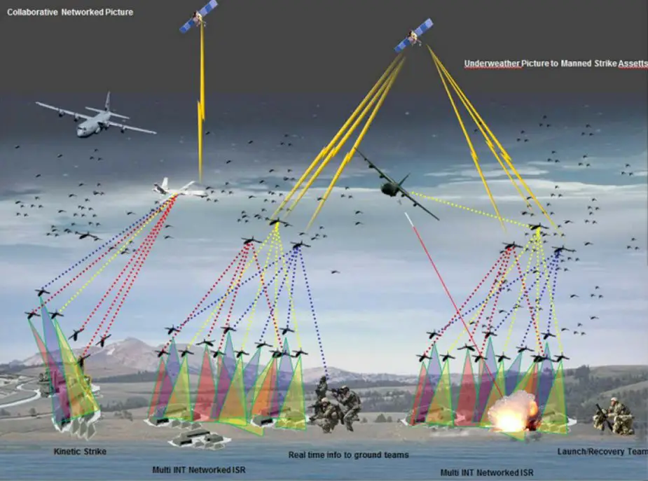
Suppressing_air_defenses_by_collective_operations_of_attack_UAVs.jpg


In terms of complexity and amount of missions to be performed, the leading positions belong to military aerospace robotic complexes (MARC). While 37 countries are engaged in development and manufacture of on-land MARC, the air- and space-borne types are, respectively, the domain of 45 and 11 countries. In the next decade, or sooner as per other estimates, the intensive use of UAVs will be standard practice in military operations. This is confirmed by numerous facts of using unmanned aerial vehicles in Afghanistan, Iraq, Yugoslavia, Libya, and Syria.

A contributing factor to development of unmanned aerial vehicles (UAVs), especially small ones, is their relatively low production and operating costs. The production cost of UAVs is 25-40% lower than that of manned vehicles while their operating cost is nearly 80% lower. In addition to these advantages there also are mobility, a possibility of rapid deployment of combat UAVs to the theater of operations, stealthy use, no personnel loss, simple operator training, plus a possibility of integrating UAVs in a single information space of the theater. Another contributing factor is progress in creation of new construction materials, light and economical engines, high technology information communication platforms and navigation systems.

Today, UAVs are classified as per their designed purpose (combat, special purpose, supporting, multi-role); control method (remotely controlled, autonomous, combined), type of aerodynamic arrangement (aircraft, helicopter, combined), source of power and other parameters. Used most often as the chief parameters are the takeoff weight and operating range (radius). The first of them divides all the vehicles in mini (up to 1 kg), small (1-30 kg), light (30-200 kg), medium (200-500 kg), and heavy (over 500 kg) class. The second does in close-in range (up to 25 km), short range (up to 100 km), medium range (up to 500 km) and long range (over 500 km).

The tasks assigned to UAV vary depending on their technical capabilities and classification. Their most important missions are aerial reconnaissance, neutralization of air defense and electronic countermeasures, radio signal communication and relay, target designation, fire correction, and assessment of damage done to enemy. In addition, UAVs can be used for search and rescue operations, minefield detection, fighting against manned and unmanned aerial vehicles, antisubmarine defense, cargo delivery, border and territory protection, and putting small spacecraft into low Earth orbit. The list of missions is determined by the vehicles’ capabilities and can be additionally specified.
Loput tästä pitkästä artikkelista linkin alla https://www.armyrecognition.com/wea..._by_collective_operations_of_attack_uavs.html
 
700 taalaa jenkeistä.

Anafi is as easy to fly as you’d expect. Plug phone into controller, turn on drone, push takeoff button, and you’re airborne. An optical sensor underneath the drone (as well as sonar) keeps it in a very steady hover, and it’ll recover quickly to that hover as soon as you stop giving it control input. It’s smooth and straightforward to fly, although a little rocky in rapid descent—I feel like that may be fixed in a software update. Anafi has no trouble in light winds; according to the specs, you can fly it in winds of up to 30 mph. Most of my test flights were in winds of 6 mph or less, which I didn’t notice in the resulting camera footage.

My flights averaged between 16 and 18 minutes in length, bringing the battery down to 25 percent—this is very much in line with Parrot’s estimate of 25 maximum flight time (at which point the drone initiates the emergency landing mode). I didn’t try the dead battery return to home, but the standard return to home works just fine. Anafi will prevent you from crashing it into the ground, and will ignore “down” inputs from the controller once it reaches an altitude of a foot or two. To land, you’ll need to push the button on the controller. I wasn’t able to test Anafi’s maximum range (advertised as 2.5 miles), because that’s well beyond my line of sight, but I had no signal issues flying the drone far away enough that I was having trouble keeping track of exactly where it was.

The video feed from the camera back to the phone is robust, and low latency, at least compared to other Wi-Fi-based drones. You’ll likely notice just a bit of lag, but in my experience, it wasn’t enough to throw off control of the drone. It might be a factor if you’re doing extreme maneuvering around obstacles, but this isn’t really the drone for aggressive obstacle dodging: It’s a drone for taking good video.
https://spectrum.ieee.org/automaton/robotics/drones/review-parrot-anafi-drone

I like this drone. I’m not really what you’d call a drone expert, and I haven’t flown the Mavic Air, which is most folks that I’ve talked to say the Anafi should be compared to. But I do have a Mavic Pro, and when I think about what drone I’d take along with me to fly for fun, it’s the Anafi.

First, flying Anafi is easy, pleasant, and low stress. The drone is quiet and stable and does what you expect it to do, while the controller and the app work reliably and give you just enough control to do what you want, but not too much more. Anafi is small, light, and quiet, helping instill a feeling of safety and confidence. Lack of obstacle avoidance sensors are a shame in the abstract, but in practice, I don’t find myself missing them all that much.

Second, Anafi is very good at doing what you buy a drone to do: take aerial pictures and video. I may not need to shoot raw or in P-LOG or whatever, but the HDR is definitely helpful, and the footage that comes directly out of the drone looks great without me having to mess with it at all, which is important since I don’t have the time, energy, or desire to mess with video very much.

Lastly, I travel with enough gear as it is, and I appreciate the fact that Anafi only adds itself. I don’t need a dedicated spare battery, charger, or a cable—the stuff I have anyway to charge my phone (USB outlet, USB-C cable, and spare battery pack) all work for Anafi as well. It doesn’t feel like a compromise, either. It just feels like how things should work.

The Parrot Anafi is available as of today for $700.
 
Like the Marine Corps, the U.S. Air Force has suspended using commercial off-the-shelf drones following a Pentagon memo released May 23.

he memo, signed by Under Secretary of Defense Patrick Shanahan, has suspended the use and purchase of commercial drones, predominantly used by Air Force Special Operations Command, according to AFSOC spokeswoman Capt. Amanda Farr.


"The Air Force as well as AFSOC is in full compliance with a memo and have ceased buying and flying commercial off-the-shelf unmanned aircraft systems," she told Military.com in a statement Thursday.

Farr said AFSOC uses the small systems for intelligence, surveillance and reconnaissance; terrain mapping; and airfield surveys. A small number of unmanned aerial systems are also used by public affairs troop for covering AFSOC stories, she said.

In all, Farr said the Air Force has stopped using approximately 70 small UAS.

While the brands were not specified, Farr said, "AFSOC employs various COTS UAS manufactured by 10 different companies. The majority of AFSOC COTS UAS are vertical-lift quadcopter type systems."

The ban was proposed after a May 14 Defense Department Inspector General report found that military units did not have sufficient procedures to evaluate or detect cybersecurity risks associated with using smaller drone systems -- some of which are produced by Chinese companies and could be embedded with malware.

"The ban will remain in effect until the Defense Department develops a strategy to adequately assess and mitigate potential cybersecurity risks associated with using COTS UAS," Farr said. "The DoD has implemented a process which allows military departments to request exemptions to the ban, on a case-by-case basis, to support urgent needs.”

The Marine Corps recently obtained an exemption in order to allow infantry squads to fly quadcopters for battlefield surveillance, according to recent reports. The quadcopters had been grounded for roughly a month in keeping with the memo.

The service had distributed about 600 InstantEye MK-2 Gen3 quadcopter systems to its rifle squads, with another 200 systems awaiting shipment when the memo was issued, Capt. Joshua Pena, spokesman for Marine Corps Combat Development Command, told Military.com on June 15.

It’s not clear that the Air Force plans to request any exemptions.

"The Air Force and AFSOC continue to purchase and operate non-COTS UAS," Farr said.
https://www.military.com/defensetec...rounds-air-force-special-ops-quadcopters.html
 
SUPER ei olekaan niin super... :D
https://www.verkkouutiset.fi/venaja...kin-taysi-floppi-simahti-17-kertaa-syyriassa/

Venäjän hurja robottitankki onkin täysi floppi: Simahti 17 kertaa Syyriassa
KASPERI SUMMANEN | 05.07.2018 | 12:48- päivitetty 05.07.2018 | 12:51
Miehittämättömän taisteluajoneuvon ominaisuuksia on liioteltu valtavasti.
Venäjä on suitsuttanut uutta Uran-9-robottitankkia suorastaan vallankumoukselliseksi kyvyksi maan asevoimille. Venäjän puolustusministeriö vahvisti maaliskuussa, että itsenäistä taisteluajoneuvoa oli myös testattu Syyriassa. Venäjän valtion mediassa on julkaistu runsaasti lennokkaita videoita (alla) Uran-9:n ”viimeisistä testeistä”. Niissä robottitankki tulittaa kohteita ja ajaa maastoradalla.
National Interestin mukaan ilma- ja panssarintorjuntaohjuksilla sekä konetykillä varustetun Uran-9:n ominaisuuksia on kuitenkin liioteltu runsaasti.
Venäläisen puolustusalan tutkija Andrei P. Anisimovin julkistamien tietojen perusteella Uran-9:n on ollut Syyrian testeissä pettymys. Kehuttu tankki ei Anisimovin mukaan yksinkertaisesti ”kykene suorittamaan sille annettuja tehtäviä”.
Defence Blog on kerännyt tähän Anisimovin venäläisessä turvallisuuskonferenssissa esittämiä kommentteja. Tutkijan mukaan Uran-9:n mainostettu toimintaetäisyys oli vain muutamia satoja metrejä alun perin luvatun noin 2,8 kilometrin sijaan.
Syyrian kokeissa koettiin myös kaikkiaan 17 lyhytaikaista ja kaksi pitkäkestoista ”hallinnan menetystä”. Tällä tarkoitetaan mitä todennäköisemmin sitä, että laite lakkasi toimimasta tai vastaamasta ohjaajansa komentoihin.
Uran-9-ajoneuvojen kerrotaan myös kärsivän runsaasti teknisistä vioista, jotka vaivaavat niin mekaanisia osia kuin myös robottitankin sensorijärjestelmiä.
 
Back
Top