https://www.popularmechanics.com/space/satellites/a16867551/machines-built-in-space/A rocket blasts off from the launchpad, carrying a couple dozen tons of cargo into space. In the span of a few minutes, the rocket accelerates to around 17,500 miles per hour, orbiting the Earth at nearly 300 miles above the surface.
What is this rocket carrying? Perhaps a communications satellite, a NASA spacecraft, or some payload for the military? Actually, the rocket isn’t even carrying a spacecraft at all. Instead, its payload contains several tons of high-grade plastic and pre-fabricated components, material that will be fed to a 3D printer waiting in orbit. This futuristic printer will then use the plastic and components to construct a functional satellite spanning several miles.
A mile-wide satellite might sound impossible, but that’s exactly where the space industry is headed. In the future, giant telescopes, communication satellites, solar arrays, and space stations will fill the space around the Earth, and many of them will be several times larger than anything ever built on the surface.
Install the app
How to install the app on iOS
Follow along with the video below to see how to install our site as a web app on your home screen.
Note: This feature may not be available in some browsers.
You are using an out of date browser. It may not display this or other websites correctly.
You should upgrade or use an alternative browser.
You should upgrade or use an alternative browser.
Avaruus
- Viestiketjun aloittaja Juke
- Aloitus PVM
tulikomento
Supreme Leader
Oletteko koskaan miettineet mitenkä rakettien ja sukkulan laukaisut oikein kuvattiin ja taltioitiin ? Tässäpä oiva vastaus.
Mullakin järeimmät objektiivit valkoisia. Ei vaan oo tota kokoluokkaa.Oletteko koskaan miettineet mitenkä rakettien ja sukkulan laukaisut oikein kuvattiin ja taltioitiin ? Tässäpä oiva vastaus.
")
jooo, tuota voi kyllä jo kutsua kiikariksi..Oletteko koskaan miettineet mitenkä rakettien ja sukkulan laukaisut oikein kuvattiin ja taltioitiin ? Tässäpä oiva vastaus.
En usko että Suomessa kannattaa hankkia Rangereille seuraajia vaan siirtyä suoraan niin tutka- kuin optisten satelliittien aikaan. Toivottavasti yhteistyössä muiden kanssa, mutta tarvittaessa vaikka yksin.
http://spacenews.com/armys-imaging-satellite-up-and-running-but-its-future-is-tbd/
"The Army experiment is being watched by the small satellite industry as a bellwether of where the military might be headed with this technology.
WASHINGTON — How valuable is it for troops in the field to have their own dedicated source of satellite imagery and other space-based intelligence? That is a question officials hope to answer in upcoming military exercises where commanders will have an opportunity to test the Army’s newly deployed Kestrel Eye microsatellite.
The Kestrel Eye Block IIM was sent into orbit in October from the International Space Station. “It is now operational,” said Dan Harkins, marketing manager at Adcole Maryland Aerospace, the satellite manufacturer.
“We expect some images in the next few weeks,” Harkins said.
Kestrel Eye is a $2 million project led by the U.S. Army Space and Missile Defense Command in Huntsville, Alabama. The Defense Department’s Space Test Program sponsored the satellite launch and deployment.
...
The small satellite system could be more responsive than traditional imaging capabilities, according to SMDC. Soldiers could access 1.5-meter resolution satellite imagery within minutes.
Kestrel Eye was launched Aug. 14 as a payload aboard the SpaceX Falcon 9 rocket as part of an International Space Station cargo resupply mission. It is orbiting 310 miles above Earth and is expected to operate for about two years."
http://space.skyrocket.de/doc_sdat/kestrel-eye-2m.htm
http://space.skyrocket.de/doc_sdat/kestrel-eye-2m.htm
https://www.adcolemai.com/
En usko että Suomessa kannattaa hankkia Rangereille seuraajia vaan siirtyä suoraan niin tutka- kuin optisten satelliittien aikaan. Toivottavasti yhteistyössä muiden kanssa, mutta tarvittaessa vaikka yksin.
http://spacenews.com/armys-imaging-satellite-up-and-running-but-its-future-is-tbd/
"The Army experiment is being watched by the small satellite industry as a bellwether of where the military might be headed with this technology.
WASHINGTON — How valuable is it for troops in the field to have their own dedicated source of satellite imagery and other space-based intelligence? That is a question officials hope to answer in upcoming military exercises where commanders will have an opportunity to test the Army’s newly deployed Kestrel Eye microsatellite.
The Kestrel Eye Block IIM was sent into orbit in October from the International Space Station. “It is now operational,” said Dan Harkins, marketing manager at Adcole Maryland Aerospace, the satellite manufacturer.
“We expect some images in the next few weeks,” Harkins said.
Kestrel Eye is a $2 million project led by the U.S. Army Space and Missile Defense Command in Huntsville, Alabama. The Defense Department’s Space Test Program sponsored the satellite launch and deployment.
...
The small satellite system could be more responsive than traditional imaging capabilities, according to SMDC. Soldiers could access 1.5-meter resolution satellite imagery within minutes.
Kestrel Eye was launched Aug. 14 as a payload aboard the SpaceX Falcon 9 rocket as part of an International Space Station cargo resupply mission. It is orbiting 310 miles above Earth and is expected to operate for about two years."
http://space.skyrocket.de/doc_sdat/kestrel-eye-2m.htm
https://www.adcolemai.com/
Minä olen tätä täällä esittänyt jo aikaa sitten mutta se ammuttiin alas huuhaa juttuna.
viestiupseeri
Alikersantti
1,5m resoluutio on jo kelvollinen. Sillä näkee ryhmitykset ja ajoneuvot. Esimerkki 0.8m resoluutiosta: https://content.satimagingcorp.com/...onos-high-resolution-satellite-image-iraq.jpg. Yksittäisiä henkilöitä tuolla on hankala havaita eikä 1,5m resoluutiolla tunnisteta eri panssarivaunuja. Mutta...
- Satelliitteja tarvitaan monta, riippuen kiertoradasta. Satelliitti pystyy kuvaamaan kohdetta vain tiettynä aikana.
- Sää ja pilvet. Satelliittia ei voi lennätää pilvien alla. Tutkakuvalla taasen ei vastaavaa resoluutiota.
- Datalinkin häirintä
- Toi $2M on yksittäisen arvioitu satelliitin hinta, projekti ja prototyyppi syönyt enemmän rahaa.
- Ei käsittääkseni live-kuvaa
Ja sitten tälläinen pikku detailji:
"Kestrel will orbit roughly 310 miles above Earth, in the same orbital plane as the space station. It’s expected to operate for a year, until atmospheric drag naturally slows it down and causes it to fall into the atmosphere and burn up." https://www.airspacemag.com/daily-planet/army-gets-ready-test-orbiting-spyglass-soldiers-180965366/
En todellakaan luopuisi omista tiedustelulennokeista ja siirtyisi pelkkien satelliittien käyttöön.
Edit: tuo vuoden-parin käyttöaika ei haittaa jos on kunnon budjetti ja mahdollisuus saada satelliitti kyytiin kun haluaa. Suomella ei moiseen pyöritykseen ole yksin mahdollisuuksia, ehkä joku Eurooppalainen yhteistyö saattaisi riittää.
Viimeksi muokattu:
1,5m resoluutio on jo kelvollinen. Sillä näkee ryhmitykset ja ajoneuvot. Esimerkki 0.8m resoluutiosta: https://content.satimagingcorp.com/...onos-high-resolution-satellite-image-iraq.jpg. Yksittäisiä henkilöitä tuolla on hankala havaita eikä 1,5m resoluutiolla tunnisteta eri panssarivaunuja. Mutta...
- Satelliitteja tarvitaan monta, riippuen kiertoradasta. Satelliitti pystyy kuvaamaan kohdetta vain tiettynä aikana.
- Sää ja pilvet. Satelliittia ei voi lennätää pilvien alla. Tutkakuvalla taasen ei vastaavaa resoluutiota.
- Datalinkin häirintä
- Toi $2M on yksittäisen arvioitu satelliitin hinta, projekti ja prototyyppi syönyt enemmän rahaa.
Ja sitten tälläinen pikku detailji:
"Kestrel will orbit roughly 310 miles above Earth, in the same orbital plane as the space station. It’s expected to operate for a year, until atmospheric drag naturally slows it down and causes it to fall into the atmosphere and burn up." https://www.airspacemag.com/daily-planet/army-gets-ready-test-orbiting-spyglass-soldiers-180965366/
En todellakaan luopuisi omista tiedustelulennokeista ja siirtyisi pelkkien satelliittien käyttöön.
Ei lennokeista voi luopua mutta pienet satelliitit ovat tulevaisuutta joihin Suomella on varaa.
viestiupseeri
Alikersantti
Jäin vielä hintaa miettimään. Satelliitti olisin sen $2M, mutta satelliitti painaa 50kg. Yhden kilon Cubesatin lähetys maksaa noin $100K, joten jos tuo menee samalla hinnalla on yksittäisen satelliitin radalle vienti sen $5M. Ei mahdottomia, vaikka joka vuosi laittaisi pari kappaletta. Muuhun infraan kuten maa-asemiin menee varmaan muutama miljoona. Mukava tuolla olisi laskea valkoisia kuorma-autoja mutta edelleenkään en pudottaisi Ranger-luokan lennokkeja pois (nopea saatavuus, pitkä toiminta-aika, live-kuva jne)
En todellakaan luopuisi omista tiedustelulennokeista ja siirtyisi pelkkien satelliittien käyttöön.
Edit: tuo vuoden-parin käyttöaika ei haittaa jos on kunnon budjetti ja mahdollisuus saada satelliitti kyytiin kun haluaa. Suomella ei moiseen pyöritykseen ole yksin mahdollisuuksia, ehkä joku Eurooppalainen yhteistyö saattaisi riittää.
Pienistä lennokeista ei kannatakaan luopua. Sen sijaan MALE / HALE -tason lennokki on Suomelle vain rajoitetusti hyödyllinen vihollisen vastatoimintakyvyn vuoksi. Live-kuvaa, henkilöiden erottamista ym. pohtiessa pitäisi varmaan myös pohtia minkä tason informaatiota kaivataan. Paikkatieto vihollisen ajoneuvoista riittänee muuhun tiedustelutietoon yhdistettynä identifioimaan tuliasemat, komentopaikat ym. sille tasolle että pitkän kantaman vaikutusta voidaan laittaa alueelle. Tiedolla siitä, kuinka monta vartiomiestä on tupakalla tai mitä ajoneuvon alamallia ajoneuvo edustaa tuskin on niin tärkeä. Tunkeutumiskykyinen stealth-lennoki kun maksaisi ilmeisesti kymmeniä tai satoja miljoonia per kappale.
Satelliittejahan saa laukaistua kun haluaa kunhan ostaa kantoraketin jotka halventuvat jatkuvasti. Optimikokoonpano olisikin varmaan rajoitettu satelliittimäärä rauhan aikana ja suurempi määrä kriisin aikana. Vielä todennäköisemmin tulevaisuudessa voisi rauhan aikana luottaa kaupalliseen kuvahankintaan ja säilyttää valmius omaan tai yhteistyössä hankittuun kapasiteettiin kriisiaikana.
Datalinkin häirintä pitää paikkansa, mutta sama pätee myös lennokkiin. Satelliitin toki voi - aikaviiveestä kärsien - ohjeistaa toisaalta dumppaamaan tiedon sitten vaikkapa maapallon toisella puolen jos vaikkapa Venäjän kohdalla on häirintää.
Jäin vielä hintaa miettimään. Satelliitti olisin sen $2M, mutta satelliitti painaa 50kg. Yhden kilon Cubesatin lähetys maksaa noin $100K, joten jos tuo menee samalla hinnalla on yksittäisen satelliitin radalle vienti sen $5M. Ei mahdottomia, vaikka joka vuosi laittaisi pari kappaletta. Muuhun infraan kuten maa-asemiin menee varmaan muutama miljoona. Mukava tuolla olisi laskea valkoisia kuorma-autoja mutta edelleenkään en pudottaisi Ranger-luokan lennokkeja pois (nopea saatavuus, pitkä toiminta-aika, live-kuva jne)
Satelliittien ja laukaisun hinta tippuu jatkuvasti. Ranger-luokan lennokki toimii hyvin selustan valvonnassa ja vastaerikoisjoukkotoiminnassa, mutta olisikohan tällöin paikka viranomaisyhteistyölle - mitkä ovat Poliisin, Rajavartiolaitoksen, ehkä jopa esim. Metlan, Trafin ja pelastuslaitosten intressit? Selviytymiskykyisiin lennokkeihin kun Suomella on tuskin varaa.
Poliisi käyttää Rangeria. Kone konsernin perijätär kun kaapattiin, niin Rangerit lentelivät Turun ilmatilassa.Pienistä lennokeista ei kannatakaan luopua. Sen sijaan MALE / HALE -tason lennokki on Suomelle vain rajoitetusti hyödyllinen vihollisen vastatoimintakyvyn vuoksi. Live-kuvaa, henkilöiden erottamista ym. pohtiessa pitäisi varmaan myös pohtia minkä tason informaatiota kaivataan. Paikkatieto vihollisen ajoneuvoista riittänee muuhun tiedustelutietoon yhdistettynä identifioimaan tuliasemat, komentopaikat ym. sille tasolle että pitkän kantaman vaikutusta voidaan laittaa alueelle. Tiedolla siitä, kuinka monta vartiomiestä on tupakalla tai mitä ajoneuvon alamallia ajoneuvo edustaa tuskin on niin tärkeä. Tunkeutumiskykyinen stealth-lennoki kun maksaisi ilmeisesti kymmeniä tai satoja miljoonia per kappale.
Satelliittejahan saa laukaistua kun haluaa kunhan ostaa kantoraketin jotka halventuvat jatkuvasti. Optimikokoonpano olisikin varmaan rajoitettu satelliittimäärä rauhan aikana ja suurempi määrä kriisin aikana. Vielä todennäköisemmin tulevaisuudessa voisi rauhan aikana luottaa kaupalliseen kuvahankintaan ja säilyttää valmius omaan tai yhteistyössä hankittuun kapasiteettiin kriisiaikana.
Satelliittien ja laukaisun hinta tippuu jatkuvasti. Ranger-luokan lennokki toimii hyvin selustan valvonnassa ja vastaerikoisjoukkotoiminnassa, mutta olisikohan tällöin paikka viranomaisyhteistyölle - mitkä ovat Poliisin, Rajavartiolaitoksen, ehkä jopa esim. Metlan, Trafin ja pelastuslaitosten intressit? Selviytymiskykyisiin lennokkeihin kun Suomella on tuskin varaa.
http://www.spacedaily.com/reports/U...o_Russian_Chinese_Missiles___Reports_999.htmlThe US Air Force is about to abandon expensive surveillance aircrafts and satellites, opting for an information network out of concerns over Russia's and China's increased space capabilities.
The United States has decided to ditch a $7 billion surveillance aircraft program in favor of an information network that connects sensors from manned and unmanned aircraft, satellites, ships at sea and ground troops.
"In a contested environment, an integrated air, space, ground network is more resilient than a single point," said Heather Wilson, Air Force Secretary, as cited by SpaceNews.
The Pentagon assumed that large and expensive satellites were more vulnerable to electronic and kinetic attacks, while smaller aircrafts would be more resilient. The Air Force believes that this concept will allow the United States to prevail in future conflicts, with the budget proposal shifting money from hardware to software.
"This budget changes the way in which we intend to execute battle management command and control," Air Force Secretary Heather Wilson said at a Mitchell Institute event on Capitol Hill on February 16.
The new satellites are expected to have more room for fuel so that they may move quickly to a different orbit or deploy countermeasures if attacked.
"A lot of the growth is going into the development and testing of new capabilities to be able to have defendable assets on orbit," Wilson added.
Such Air Force weapons systems as the airliner-size JSTARS radar surveillance aircrafts were deemed easy targets in a potential conflict due to the fact that Russia and China were developing high-speed missiles, advanced ground and space-based surveillance technologies.
Earlier in February, the Office of the Director of National Intelligence presented a report on Russia's and China's space capabilities.
"Foreign countries - particularly China and Russia - will continue to expand their space-based reconnaissance, communications, and navigation systems in terms of the numbers of satellites, the breadth of their capability, and the applications for use," said the 2018 Worldwide Threat Assessment of the US Intelligence Community.
US intelligence also predicted that "destructive" Russian and Chinese anti-satellite weapons probably would reach "initial operational capability in the next few years."
Viimeksi muokattu:
Siis poliisi sai Puolustusvoimilta tuon virka-apuna.Poliisi käyttää Rangeria. Kone konsernin perijätär kun kaapattiin, niin Rangerit lentelivät Turun ilmatilassa.
http://www.theregister.co.uk/2018/03/01/paul_allen_stratolaunch_satellite_launch_plane_test/The world's largest aircraft, designed to one day fling rockets into space, has tested out its taxiing capabilities at the Mojave Air and Space Port in New Mexico.
The 500,000lb (227 metric ton) "Stratolaunch" is the brainchild of Microsoft co-founder Paul Allen and advanced materials aviation wizard Burt Rutan. The pair plan to carry rockets up to high altitude before they fall free, fire up, and deliver cargo into low-Earth orbit. Using Bernoulli's Principle to do the heavy lifting for the first few kilometres saves rockets the fuel-intensive and very stressful early moments of flight.
Allen has sunk $300m into the much-delayed project, but on Sunday it rolled out of the hangar.
Tutustukaapa @StmSvejk @Talvela @viestiupseeri Iceye-nimiseen firmaan.
On totta että Suomella ei ole varaa rakentaa valtion budjetista valvonta-satelliittikonstellaatiota. Yksityisellä rahalla kyllä on, eikä se vaadi kuin sen että niillä satelliiteilla voi tehdä rahaakin tiedustelutiedon lisäksi. Iceyen ensimmäinen satelliitti on jo avaruudessa ja tuottaa kuvaa 10 metrin resoluutiolla. Yrityksen tavoite on päästä 3 metrin resoluutioon ja palveluja markkinoidaan moneen tarkoitukseen. Ensimmäinen markkina-ajatus oli jäätilanteen raportointi kauppamerenkulun tarpeisiin, mutta mielenkiintoisempi idea on autokaupan kuljetusten seuranta, eli mm. autojen sijaintien tarkkailu satamien säilytyskentillä. Jos tuo onnistuu, niin onnistuu myös Iskander-laukaisimien laskeminen Lugasta.")
Juu, reaaliaikaiseen maalitukseen tarvitaan paljon enemmän kuin puolentusinaa tutkasatelliittia - mutta noillakin saadaan jo paljon arvokasta tietoa, ja se on alku muuhun.
On totta että Suomella ei ole varaa rakentaa valtion budjetista valvonta-satelliittikonstellaatiota. Yksityisellä rahalla kyllä on, eikä se vaadi kuin sen että niillä satelliiteilla voi tehdä rahaakin tiedustelutiedon lisäksi. Iceyen ensimmäinen satelliitti on jo avaruudessa ja tuottaa kuvaa 10 metrin resoluutiolla. Yrityksen tavoite on päästä 3 metrin resoluutioon ja palveluja markkinoidaan moneen tarkoitukseen. Ensimmäinen markkina-ajatus oli jäätilanteen raportointi kauppamerenkulun tarpeisiin, mutta mielenkiintoisempi idea on autokaupan kuljetusten seuranta, eli mm. autojen sijaintien tarkkailu satamien säilytyskentillä. Jos tuo onnistuu, niin onnistuu myös Iskander-laukaisimien laskeminen Lugasta.
Juu, reaaliaikaiseen maalitukseen tarvitaan paljon enemmän kuin puolentusinaa tutkasatelliittia - mutta noillakin saadaan jo paljon arvokasta tietoa, ja se on alku muuhun.
Tutustukaapa @StmSvejk @Talvela @viestiupseeri Iceye-nimiseen firmaan.
On totta että Suomella ei ole varaa rakentaa valtion budjetista valvonta-satelliittikonstellaatiota. Yksityisellä rahalla kyllä on, eikä se vaadi kuin sen että niillä satelliiteilla voi tehdä rahaakin tiedustelutiedon lisäksi. Iceyen ensimmäinen satelliitti on jo avaruudessa ja tuottaa kuvaa 10 metrin resoluutiolla. Yrityksen tavoite on päästä 3 metrin resoluutioon ja palveluja markkinoidaan moneen tarkoitukseen. Ensimmäinen markkina-ajatus oli jäätilanteen raportointi kauppamerenkulun tarpeisiin, mutta mielenkiintoisempi idea on autokaupan kuljetusten seuranta, eli mm. autojen sijaintien tarkkailu satamien säilytyskentillä. Jos tuo onnistuu, niin onnistuu myös Iskander-laukaisimien laskeminen Lugasta.
Juu, reaaliaikaiseen maalitukseen tarvitaan paljon enemmän kuin puolentusinaa tutkasatelliittia - mutta noillakin saadaan jo paljon arvokasta tietoa, ja se on alku muuhun.
Kuullostaa kyllä siltä että tuollaiseen voisi saada rahaa monesta eri ministeriöstä.
Fremen
Greatest Leader
Tässä hienoja, osin klassisiakin kuvia uudesta 'Space Exploration' -kirjasta (Carolyn Collins Petersen):
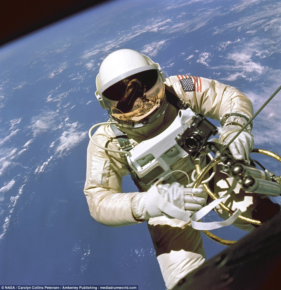
Fascinating retro photographs that take you on a journey from the first brave space pioneers through to the incredible technological advances of today have been revealed in a new book. Pictured is Ed White performing the first American spacewalk on March 18, 1965
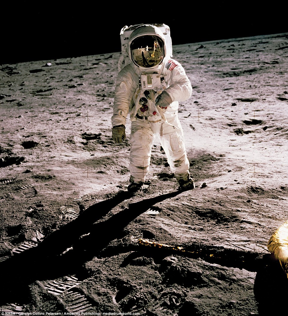
Captivating photographs include a snap of Edwin Eugene 'Buzz' Aldrin - the second man on the moon - walking on the lunar surface during the Apollo 11 mission on July 21, 1969. The image (pictured) was taken by Neil Armstrong, who was the first person to walk on the moon
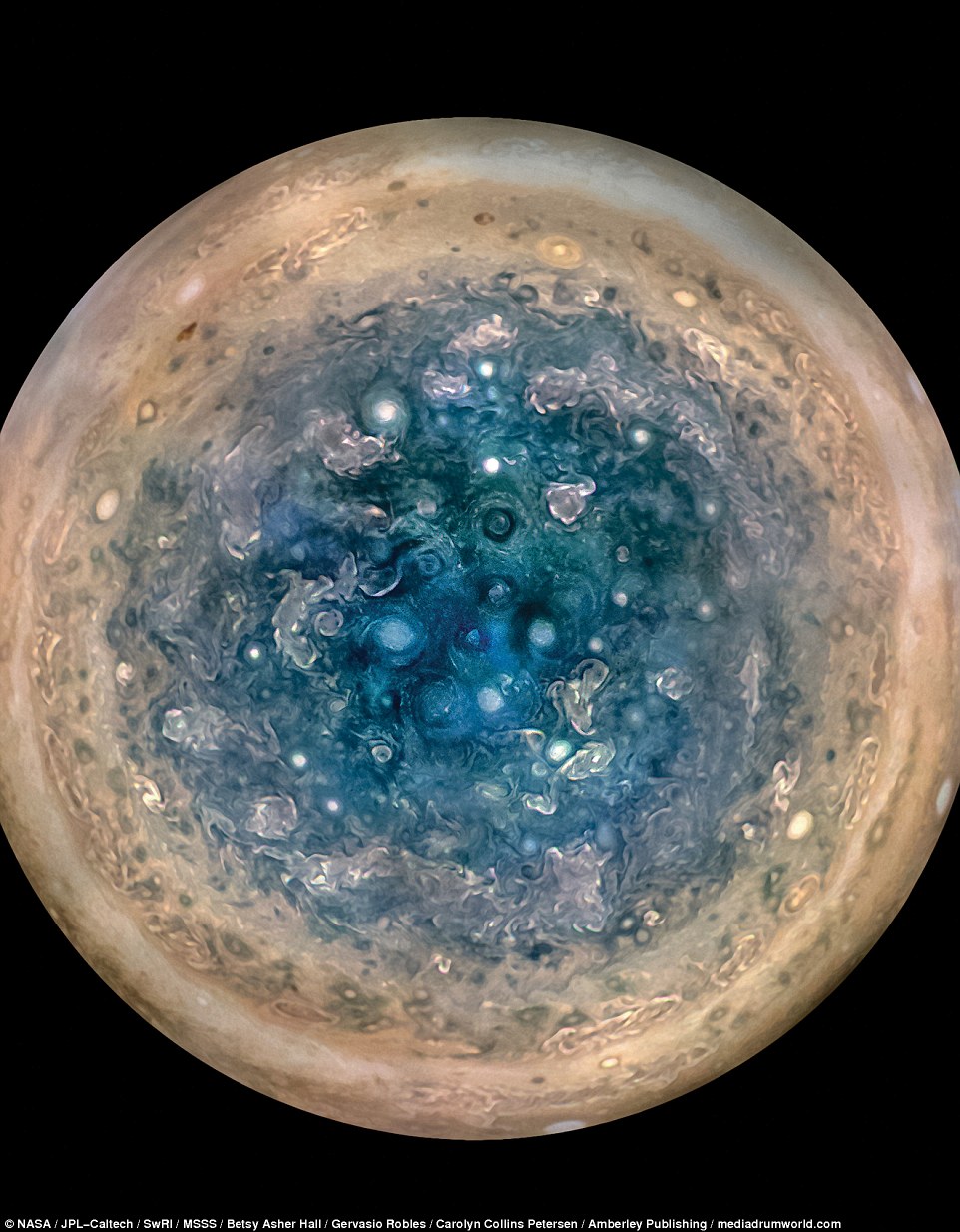
Other images show Jupiter's south pole (pictured), as seen by Nasa's Juno spacecraft from an altitude of 32,000 miles (52,000km) in May 2017
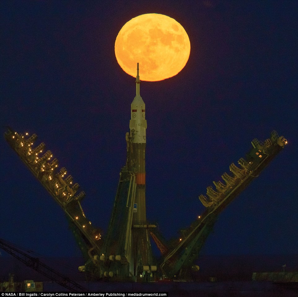
This image shows Russia's soyuz Rocket pictured in front of a supermoon at the Baikonur Cosmodrome launchpad in Kazakhstanon on November 18, 2016. The incredible pictures are part of a new book called 'Space Exploration' by Colorado-based writer and producer Carolyn Collins Petersen
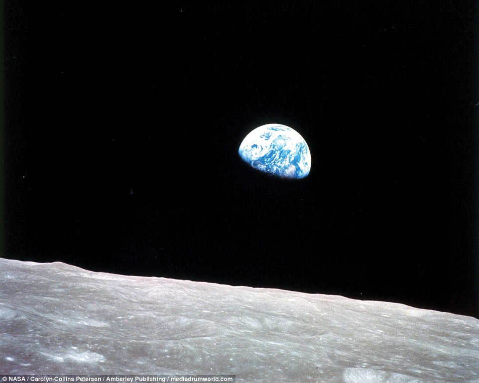
Pictured is the Earth as seen from the moon's orbit during the Apollo 8 mission on Christmas Eve of 1968. The mission became the first manned spacecraft to leave Earth orbit, reach the Earth's Moon, orbit it and return safely to Earth
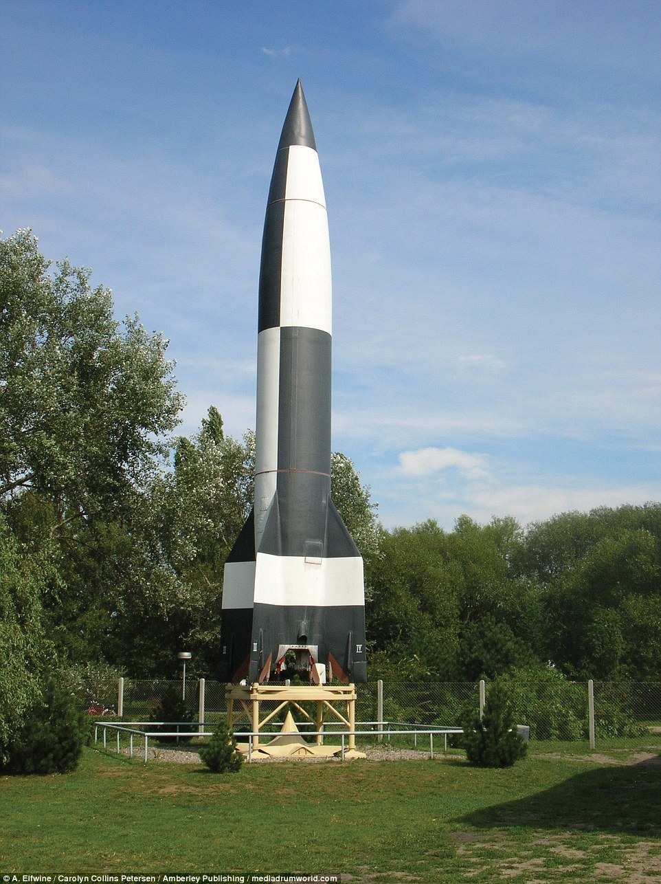
The V-2 rocket was the world's first long-range guided ballistic missile. Developed by German engineers during World War 2, the device paved the way for a 20th century boom in rocket technology
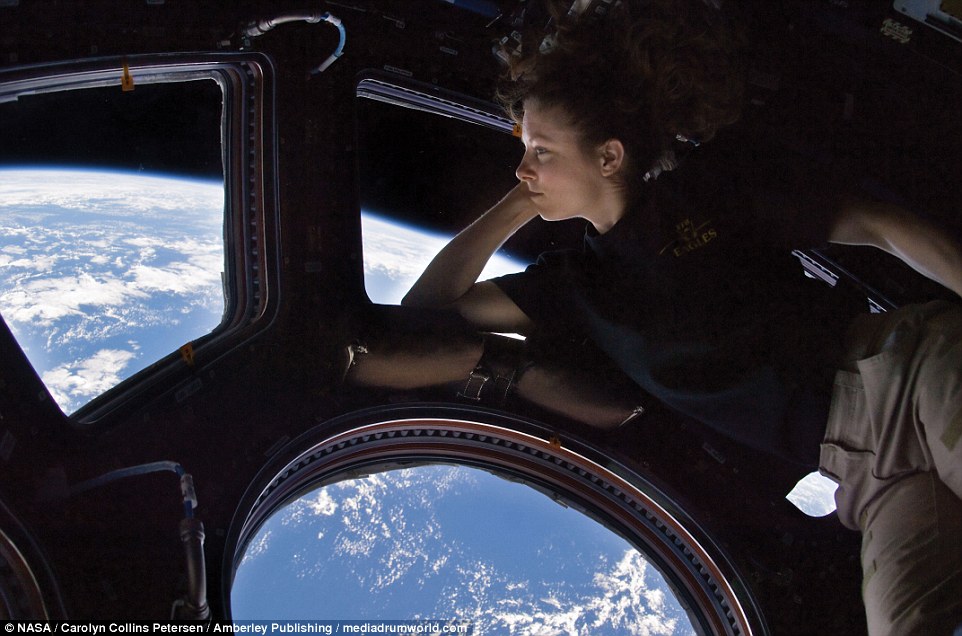
In this picture, Nasa astronaut Tracey Caldwell Dyson looks through a window in the Cupola of the International Space Station (ISS). The ISS is a $100 billion (£80 billion) science and engineering laboratory that orbits 250 miles (400 km) above Earth. It has been permanently staffed by rotating crews of astronauts and cosmonauts since November 2000
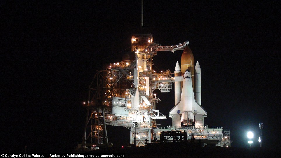
Space Shuttle Endeavour is a retired orbiter from Nasa's Space Shuttle programme and the fifth and final operational shuttle built by the agency. It embarked on its first mission in May 1992. Pictured is Endeavour on the night before its last launch on June 1, 2011
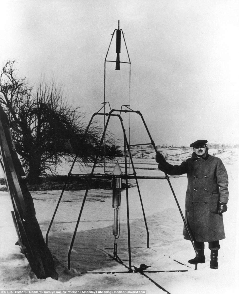
Robert H. Goddard, the American father of modern rocketry, built and tested the world's first liquid-fuel rocket in 1926. Pictured is Dr Goddard and his liquid oxygen-gasoline rocket on March 8, 1926
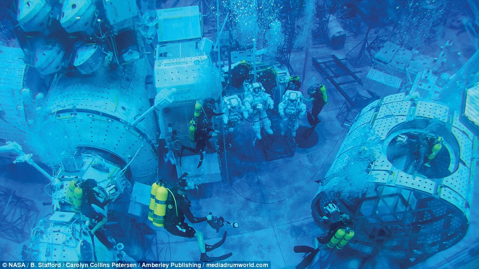
Astronaut candidates train for extravehicular activity in the Neutral Buoyancy Lab at Nasa's Johnson Space Centre in Houston. As it is difficult to train astronauts in zero-gravity, the agency frequently uses water tanks instead
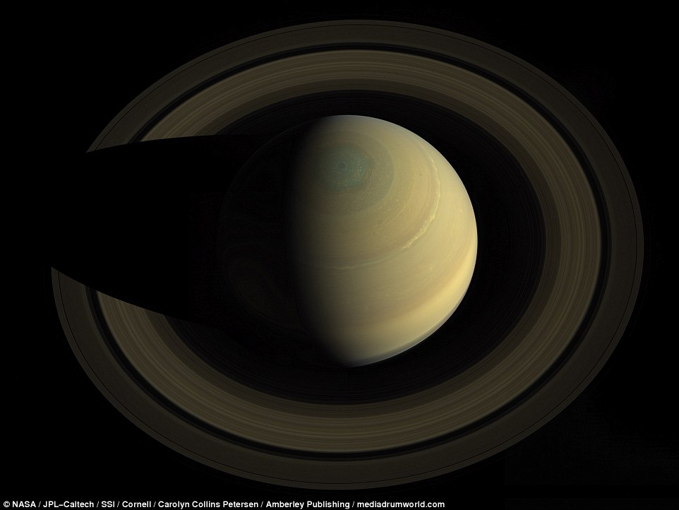
NASA's Cassini spacecraft took this image of Saturn and its main rings. The view, which is a composite of several images that have been edited, is natural colour, as human eyes would see it from this range
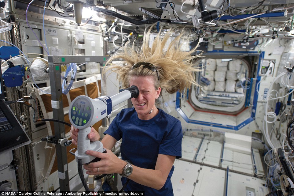
Visual Impairment Intracranial Pressure (VIIP) Syndrome is a conditions that affects the eyes of astronauts that was identified in 2005. It describes the loss of some sight capabilities as a result of long periods spent in micro-gravity, and is considered a spaceflight risk by Nasa. In this image, Nasa astronaut Karen Nyberg uses a 'fundoscope' to detect the condition
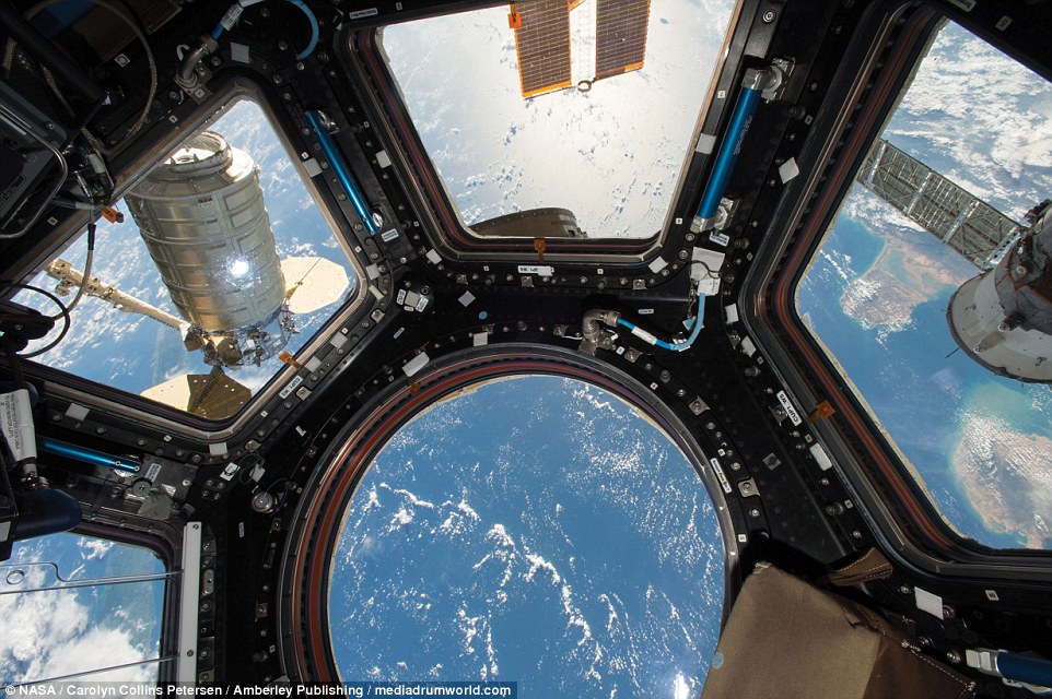
This image shows a view through the International Space Station's cupola on October 23, 2016. The space station is currently home to two Russians, three Americans and one Japanese. Research conducted aboard the ISS often requires one or more of the unusual conditions present in low Earth orbit, such as low-gravity or oxygen
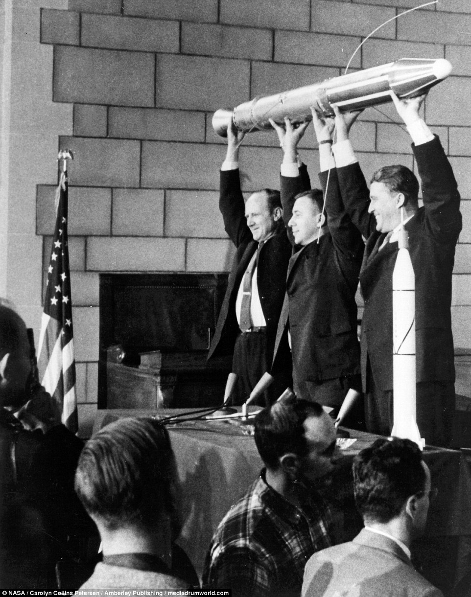
Pictured are the creators of the Explorer 1 spacecraft holding a model of it at the launch press conference on launch day on January 31, 1958. Explorer 1 was the first satellite launched by the United States when it was sent into space. Its primary science instrument on Explorer 1 was a cosmic ray detector designed to measure the radiation environment in Earth orbit
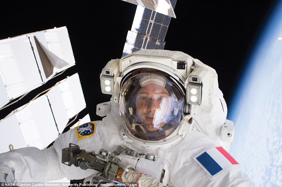
This image shows European Space Agency astronaut Thomas Pesquet during a spacewalk in Jan 2017
Fascinating retro photographs that take you on a journey from the first brave space pioneers through to the incredible technological advances of today have been revealed in a new book. Pictured is Ed White performing the first American spacewalk on March 18, 1965
Captivating photographs include a snap of Edwin Eugene 'Buzz' Aldrin - the second man on the moon - walking on the lunar surface during the Apollo 11 mission on July 21, 1969. The image (pictured) was taken by Neil Armstrong, who was the first person to walk on the moon
Other images show Jupiter's south pole (pictured), as seen by Nasa's Juno spacecraft from an altitude of 32,000 miles (52,000km) in May 2017
This image shows Russia's soyuz Rocket pictured in front of a supermoon at the Baikonur Cosmodrome launchpad in Kazakhstanon on November 18, 2016. The incredible pictures are part of a new book called 'Space Exploration' by Colorado-based writer and producer Carolyn Collins Petersen
Pictured is the Earth as seen from the moon's orbit during the Apollo 8 mission on Christmas Eve of 1968. The mission became the first manned spacecraft to leave Earth orbit, reach the Earth's Moon, orbit it and return safely to Earth
The V-2 rocket was the world's first long-range guided ballistic missile. Developed by German engineers during World War 2, the device paved the way for a 20th century boom in rocket technology
In this picture, Nasa astronaut Tracey Caldwell Dyson looks through a window in the Cupola of the International Space Station (ISS). The ISS is a $100 billion (£80 billion) science and engineering laboratory that orbits 250 miles (400 km) above Earth. It has been permanently staffed by rotating crews of astronauts and cosmonauts since November 2000
Space Shuttle Endeavour is a retired orbiter from Nasa's Space Shuttle programme and the fifth and final operational shuttle built by the agency. It embarked on its first mission in May 1992. Pictured is Endeavour on the night before its last launch on June 1, 2011
Robert H. Goddard, the American father of modern rocketry, built and tested the world's first liquid-fuel rocket in 1926. Pictured is Dr Goddard and his liquid oxygen-gasoline rocket on March 8, 1926
Astronaut candidates train for extravehicular activity in the Neutral Buoyancy Lab at Nasa's Johnson Space Centre in Houston. As it is difficult to train astronauts in zero-gravity, the agency frequently uses water tanks instead
NASA's Cassini spacecraft took this image of Saturn and its main rings. The view, which is a composite of several images that have been edited, is natural colour, as human eyes would see it from this range
Visual Impairment Intracranial Pressure (VIIP) Syndrome is a conditions that affects the eyes of astronauts that was identified in 2005. It describes the loss of some sight capabilities as a result of long periods spent in micro-gravity, and is considered a spaceflight risk by Nasa. In this image, Nasa astronaut Karen Nyberg uses a 'fundoscope' to detect the condition
This image shows a view through the International Space Station's cupola on October 23, 2016. The space station is currently home to two Russians, three Americans and one Japanese. Research conducted aboard the ISS often requires one or more of the unusual conditions present in low Earth orbit, such as low-gravity or oxygen
Pictured are the creators of the Explorer 1 spacecraft holding a model of it at the launch press conference on launch day on January 31, 1958. Explorer 1 was the first satellite launched by the United States when it was sent into space. Its primary science instrument on Explorer 1 was a cosmic ray detector designed to measure the radiation environment in Earth orbit
This image shows European Space Agency astronaut Thomas Pesquet during a spacewalk in Jan 2017
Captivating photographs include a snap of Edwin Eugene 'Buzz' Aldrin - the second man on the moon - walking on the lunar surface during the Apollo 11 mission on July 21, 1969. The image (pictured) was taken by Neil Armstrong, who was the first person to walk on the moon
vähemmän yllättäen tuosta kuvasta tulee mieleen tämä:
Aikamme Isac Newton, Stephen Hawking menehtyi viime yön aikana Suomen aikaa.
Yksi ihmiskunnan kirkkaimmista mielistä on postunut keskuudesta, mutta hän inspiroi tuhansia mieliä seuraamaan tieteen kutsumusta.
Yksi ihmiskunnan kirkkaimmista mielistä on postunut keskuudesta, mutta hän inspiroi tuhansia mieliä seuraamaan tieteen kutsumusta.