teknohippi
Ylipäällikkö
Ukraina on aikaisemminkin ilmeisesti käyttänyt Patriot patteria lähellä rintamaa. Jos tuo pudostupaikka pitää paikkansa niin kyllähän tuo on Patriotin kantamalla, varsinkin kun kohde on selkeästi tutkahorisontin yläpuolella mutta ei mahdottoman korkealla.Yksi arvio A-50U koneen sijainnille ennen pudotusta:
It appears an aircraft was actively orbiting at the time of this image 2024-01-14 08:19:45 UTC. Unfortunately it's under a cloud so we can't identify the type. This image was taken roughly 12 hours before the reports of the downed A-50 and IL-22 started to appear, roughly 20:47 UTC.
The first account I saw reporting this was from @olga_pp98 who uses radio monitoring as a source. If these reports were received by radio intercept, it would make sense for the alleged shoot down time to be close to the report time.
This is all the information we have at the moment. We should be able to use this image and the aircraft location to do some calculations on contrail movement and establish the rough original orbit location. However that won't verify these claims, we will need more evidence or official information.
Image: USGS / Landsat-8
(kuvan tarkempi versio twitterissä)
Katso liite: 91470
-
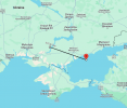
Kuvassa mainitut 46.43916, 36.26325 koordinaatit kartalla (hyvin lähellä rantaviivaa siis):
Katso liite: 91471
Näistä ryssän awacseista on väitetty että lentävät aina samaa reittiä, niin kyllähän tuolla paikalla on suoraan kerjätty Ukrainaa kokeilemaan Patriottia.
Historiasta löytyy tosin tapaus jossa ryssäläinen IT huijattiin ampumaan ryssän Awacs alas, täm tapahtui taannoin Syyriassa ja Israelin toimesta. En pidä nykytilanteessa sitä mitenkään mahdottomana että Israel on ystävällisesti jakanut tekniset tiedot tästä. Eli miten se huijaus tehdään. Kertsin salmen IT yltää tuohon oletettuun tippumispaikkaan hyvin.
Jos tiedot pitää paikkansa niin kyllähän tämä alkaa vaikuttaa suoraviivaiselta Patriotin käytöltä loppujen lopuksi.


 Eeppinen viikko tulossa.


